
The municipal plan's provisions for land allocations
The municipal plan establishes the following “municipal plan provisions”, which apply to the entire municipality, i.e. all sub-areas in the entire Municipality Qeqertalik. The provisions of the municipal plan apply unless otherwise stipulated in the general Framework Provisions Detailed Local Plan Provisions in Local Plans for the individual sub-areas. The provisions of the municipal plan provisions are binding for the municipal council’s planning and administration of land use, unless otherwise stipulated in either the General Framework Provisions or in Detailed Local Plan Provisions in a Local Plan. The municipal plan shall establish general Framework Provisions for all sub-areas in the municipality and detailed Local Plan Provisions in Local Plans, which set out the framework for the physical activities and the subsequent Land Administration.
General framework provisions
- Based on the Government's statutory consolidation of the Inatsisartutlov on Planning and Land Use no. 4 of 25 January 2025, a number of general, overarching Framework Provisions are established.
- The General Framework Provisions for the individual sub-areas are included in the main structure.
- The Detailed Local Provisions must not conflict with the overall Framework Provisions.
Detailed Local Plan provisions for land allocations
- In settlements with 500 inhabitants or more, a local plan must be prepared before land allocations can be issued.
- In settlements with fewer than 500 inhabitants, land allocations can be issued without the preparation of Local Plans.
The provisions of the municipal plan apply to all sub-areas of the municipality in cities, settlements and the open countryside. The provisions are general and do not take into account the local conditions in the sub-areas. The goal of having such provisions is to provide citizens with fundamentally uniform basic provisions with uniform conditions in all cities, settlements and the open countryside. The provisions of the municipal plan provisions provide common guidelines for the specific planning and land administration in all cities, settlements and the open countryside. For each sub-area in cities, settlements and the open countryside, specific overall provisions also apply, which are adapted to local conditions and needs and in many cases supplemented with special provisions for conservation, access and insight, etc.
of the detailed provisions is to elaborate on the general guidelines of the municipal plan and to specify what may happen within a more precisely defined sub-area. Detailed provisions cannot therefore be laid down for matters that contradict the general provisions. Detailed provisions must be drawn up before land can be allocated for major or significant construction or civil engineering works and before demolition of major or significant buildings.
Area types
The delimitation of sub-areas is determined according to the primary use. The sub-areas in the cities are designated within the use categories AE, while the sub-areas in the open countryside are designated within the categories KO. The uses are determined as follows:
A: Residential areas
B: Commercial and port areas
C: Downtown areas
D: Open areas and recreational facilities
E: Technical facilities and infrastructure
K: Cabins, holiday homes, etc.
L: Special recreational areas
M: Animal husbandry and agriculture
N: Technical facilities
O: Reserved areas
Municipal plan provisions have been prepared for the individual area types, as well as municipal plan provisions for conditions that apply to all area types.
Municipal plan provisions for area types AE
The delimitation of sub-areas is determined according to the primary use.
A: Residential areas
Residential areas include both existing and new residential areas. In the main structure, areas are laid out for different types of housing and associated common facilities such as parking, living and play areas.
Open-plan residential development
Open-low residential development means single-family houses and two-family houses/semi-detached houses with a maximum of 2 floors. A single-family house comprises one dwelling and a two-family house/semi-detached house comprises 2 dwellings.
In connection with open-low residential buildings, an area of a maximum of 50 m2 can be allocated for a garden, open terrace, etc., directly adjacent to the home.
Garages, carports, outbuildings, greenhouses, winter gardens, covered terraces, etc. of up to 30 m2 total area may be permitted in close proximity to the individual residence, provided that the building regulations' distance requirements for the area in question are complied with. A maximum of 50 m² terrace may be established in connection with a residence, of which 30 m² may be covered.
Area allocation for gardens, terraces, garages, outbuildings, etc. can be announced if the terrain, boundary distances with respect to buildings and roads, and neighbors' access and visibility conditions allow for this.
Dense - low-rise residential development
Dense - low-rise residential development means terraced, chain and cluster houses with a maximum of 3 floors, corresponding to two full floors and utilized attic.
In connection with dense, low-rise residential development, an area of a maximum of 25 m2 per dwelling may be allocated for a garden, open terrace, etc. in direct connection with the dwelling.
In connection with a residence in a dense, low-rise residential development, garages, carports, outbuildings, greenhouses, winter gardens, covered terraces, etc. of up to 20 m2 total area may be permitted, provided that the distance requirements of the building regulations and the provisions of the sub-area plan for the area in question are complied with.
Area allocation for gardens, terraces, garages, outbuildings, etc. can be announced if the terrain, boundary distances with respect to buildings and roads, and neighbors' access and visibility conditions allow for this.
Apartment building
Multi-story residential buildings mean block, log, block buildings and point houses of 3 floors or higher.
Mixed residential area
Mixed residential areas are defined as an area with a mixture of open-low, dense-low and multi-story residential buildings.
Gardens
Areas may be set aside for gardens if the Municipal Council deems it possible and compatible with the area's other use and provided that the overall spaciousness of the individual sub-area is maintained.
Playgrounds
When establishing residential developments, areas must be set aside for children's playgrounds. In an area allocation, it may be required that the playgrounds be established before the homes are put into use.
Undeveloped areas in residential areas
Undeveloped areas that are not zoned for other purposes may only be developed and used as common open spaces.
Setting up shared tables and benches
The Municipal Council may permit the installation of tables and benches for communal use, provided that the following conditions are met:
- It must be possible and compatible with the other uses of the area.
- The overall use of the individual sub-area must be maintained.
- The installation must not cause visibility problems or noise nuisance for the use of the area.
The use of undeveloped areas is subject to the current regulations and bylaws for boat storage and cat and dog keeping in Municipality Qeqertalik. Provisions regarding the placement of containers are regulated via the area allocation.
Other activities in residential areas
The Municipal Council may permit the establishment of businesses in residential areas that can normally be carried out in residential areas, provided that the following conditions are met:
- The business must be operated in such a way that the area's character as a residential area is not disrupted, including through signage and lighting.
- The company must not cause nuisance to the surrounding residents, for example in the form of smoke and odor nuisance.
- The business must not result in a noticeably increased need for parking.
- The company must not prevent the establishment of a childcare institution in the area.
Regardless of provisions in older Local Plans and municipal plan supplements, based on the above, businesses can be established in residential areas.
In residential areas, open spaces, residential buildings, communal buildings, childcare institutions, convenience stores and facilities for the area's technical supply can be incorporated.
In residential areas, it must be ensured that access to the individual home is appropriate, including for water supply and collection of household waste.
Expansion and extension in fully developed areas
In areas that are fully developed without vacant land, existing buildings can be expanded or remodeled without requiring a new planning basis. However, applicable general framework regulations and detailed local planning regulations must be complied with.
Construction sites and documentation requirements
- Laying out of building plots: The size is determined based on existing buildings and the conditions of the undeveloped area.
- Size: The building site must allow for development in accordance with relevant requirements, including access conditions and distance regulations.
- Scope and distance: The relationship between the height of the building and the distance to neighboring buildings must ensure sufficient space for functionality and safety.
- Unqualified proposals: The Municipal Council may reject a building site if it does not allow for development that complies with necessary access and distance requirements.
- Distances: The distance between buildings and neighboring buildings, roads and paths is determined based on safety considerations, including the risk of fire spread and the availability of rescue services.
- Building heights: Satisfactory distances must ensure that the height of the building is in appropriate proportion to the distance to neighboring buildings and access roads.
- Road construction lines: The distance of buildings from the center of the road must ensure sufficient access and meet fire prevention and rescue requirements.
- Fire compartmentation: Special consideration must be given to fire compartmentation and the need to maintain functional distances between buildings, especially for smaller buildings such as sheds and garages.
B: Industrial and port areas
A distinction is made between business areas and business and port areas. Common to both types of B areas is the dependence on direct access to the primary road network.
Business areas
Areas for commercial purposes can be used for offices, construction companies, warehouses and storage, crafts, workshops, production, transport, industry, warehousing, wholesale trade and technical facilities.
Business and port areas
Areas for commercial and/or port purposes can be used for offices, construction companies, warehouses and storehouses, crafts, workshops, production, transport, industry, warehousing, wholesale trade, quay and pier facilities, shipyards, terminal functions and technical facilities.
Measures must be taken to limit any smoke, noise, dust and odor nuisance.
In B areas, companies with special location requirements can be established, including particularly polluting companies (Chapter 5 companies). In each case, measures must be taken to prevent environmental impacts on the surroundings, including wastewater, landfilling of oil, chemical and metal waste.
Furthermore, storage and the like can be established with containers, equipment and materials, etc., but may not be used for landfills, landfills, etc.
Expansion and extension in fully developed areas
In areas that are fully developed without vacant land, existing buildings can be expanded or remodeled without requiring a new planning basis. However, applicable general framework regulations and detailed local planning regulations must be complied with.
Construction sites and documentation requirements
- Laying out of building plots: The size is determined based on existing buildings and the conditions of the undeveloped area.
- Size: The building site must allow for development in accordance with relevant requirements, including access conditions and distance regulations.
- Scope and distance: The relationship between the height of the building and the distance to neighboring buildings must ensure sufficient space for functionality and safety.
- Unqualified proposals: The Municipal Council may reject a building site if it does not allow for development that complies with necessary access and distance requirements.
- Distances: The distance between buildings and neighboring buildings, roads and paths is determined based on safety considerations, including the risk of fire spread and the availability of rescue services.
- Building heights: Satisfactory distances must ensure that the height of the building is in appropriate proportion to the distance to neighboring buildings and access roads.
- Road construction lines: The distance of buildings from the center of the road must ensure sufficient access and meet fire prevention and rescue requirements.
- Fire compartmentation: Special consideration must be given to fire compartmentation and the need to maintain functional distances between buildings, especially for smaller buildings such as sheds and garages.
C: Center areas and areas for common purposes
Center areas
In central areas, urban functions can be incorporated such as shops, liberal professions (advertising agencies, IT companies, lawyers, architects, engineers, real estate agents, accountants and the like), clinics (dentist, podiatrist, psychologist and the like), services, public administration, housing, hotel, restaurant, parking and necessary technical facilities, etc. Non-environmentally polluting types of business can also be incorporated such as workshops and craft businesses, warehouses, transport, etc.
Undeveloped areas that are not zoned for other purposes may only be developed and used as common public open spaces and must be designed in a way that is in harmony with the location and use of the area.
Common purpose
Common purposes include schools/education, institutions for children, young people and the elderly, churches, public administration, housing, cultural purposes, leisure and recreational purposes, parking and necessary technical facilities, etc.
Undeveloped areas that are not zoned for other purposes may only be developed and used as common public open spaces and must be designed in a way that is in harmony with the location and use of the area.
Setting up shared tables and benches
The Municipal Council may permit the installation of tables and benches for communal use, provided that the following conditions are met:
- It must be possible and compatible with the other uses of the area.
- The overall use of the individual sub-area must be maintained.
- The installation must not cause visibility problems or noise nuisance for the use of the area.
Expansion and extension in fully developed areas
In areas that are fully developed without vacant land, existing buildings can be expanded or remodeled without requiring a new planning basis. However, applicable general framework regulations and detailed local planning regulations must be complied with.
Construction sites and documentation requirements
- Laying out of building plots: The size is determined based on existing buildings and the conditions of the undeveloped area.
- Size: The building site must allow for development in accordance with relevant requirements, including access conditions and distance regulations.
- Scope and distance: The relationship between the height of the building and the distance to neighboring buildings must ensure sufficient space for functionality and safety.
- Unqualified proposals: The Municipal Council may reject a building site if it does not allow for development that complies with necessary access and distance requirements.
- Distances: The distance between buildings and neighboring buildings, roads and paths is determined based on safety considerations, including the risk of fire spread and the availability of rescue services.
- Building heights: Satisfactory distances must ensure that the height of the building is in appropriate proportion to the distance to neighboring buildings and access roads.
- Road construction lines: The distance of buildings from the center of the road must ensure sufficient access and meet fire prevention and rescue requirements.
- Fire compartmentation: Special consideration must be given to fire compartmentation and the need to maintain functional distances between buildings, especially for smaller buildings such as sheds and garages.
Setting up shared tables and benches
The Municipal Council may permit the installation of tables and benches for communal use, provided that the following conditions are met:
- It must be possible and compatible with the other uses of the area.
- The overall use of the individual sub-area must be maintained.
- The installation must not cause visibility problems or noise nuisance for the use of the area.
D: Open spaces, recreational areas and leisure facilities
Reserved area
Reserved areas are areas that are reserved for development and are used for recreational purposes – e.g. urban nature areas, common open space, green areas/parks, areas for keeping dogs, etc.
Leisure facilities and recreational areas
Areas for recreational facilities include functions such as sports facilities, ski facilities, marinas, shooting ranges, tent sites, museum and exhibition areas, cemeteries, etc.
The reserved areas and areas for recreational facilities must be reserved for development other than that necessary for the use and operation of the area. This does not prevent the implementation of the roads, paths, wiring and technical installations specified in the main structure, such as telecommunications, navigation, technical observation and wiring systems, as well as smaller facilities necessary for the use of the areas for fishing and hunting, as well as recreational purposes.
Setting up shared tables and benches
The Municipal Council may permit the installation of tables and benches for communal use, provided that the following conditions are met:
- It must be possible and compatible with the other uses of the area.
- The overall use of the individual sub-area must be maintained.
- The installation must not cause visibility problems or noise nuisance for the use of the area.
In D areas, hotels and cabin villages can also be planned in connection with recreational facilities of tourist interest, as well as infrastructure facilities.
The areas' scenic and recreational values must be preserved.
E: Technical facilities and infrastructure
Areas for technical installations and infrastructure are often areas covered by Chapter 5 of the Environmental Protection Act or functions with safety risks for adjacent areas. In each case, measures must be taken to prevent environmental impact on the surroundings, including wastewater, landfilling of oil, chemical and metal waste.
Technical facilities
The areas include major technical facilities such as waterworks, dumps, night cleaning, oil tank facilities, telecommunications facilities, explosives depots, quarries, waste incineration plants, etc.
In connection with supply facilities (waterworks, dump, night cleaning, etc.), smaller buildings in the form of crew sheds of up to 20 m2 and with a maximum tipping height of 6 meters may be constructed, when the distance requirements of the building regulations and the provisions of the sub-area plan for the area in question are complied with.
In sub-areas that are designated for technical purposes in the form of waste management and the like, areas and facilities for source sorting and recycling can be developed, incineration plants and associated functions and buildings can be constructed.
Areas and facilities for wastewater management, treatment and discharge, as well as associated functions and buildings, can be developed in sub-areas that are designated for technical purposes in the form of nighttime renovation.
This must be implemented in accordance with applicable sector plans, regulations, etc., as well as the provisions for the sub-area in question and applicable rules (area allocation, building regulations and other relevant legislation).
The Greenland Government may approve the collection and quarrying of stone, gravel and similar materials for local use as road and building materials in accordance with the rules in sections 46 and 47 of the Mineral Resources Act. The Greenland Government may set conditions for the exploitation. The Municipal Council may grant land allocation in accordance with the rules.
Infrastructure facilities
The areas include major infrastructure facilities such as airports, heliports, fixed port facilities, major road facilities, tunnels, cable cars, etc.
The municipal plan's provisions for all area types
Restricted zones
Restricted zones are established by the relevant authorities, either to protect technical installations or to protect drinking water.
Provisions in connection with a restricted zone or safety zone around, for example, water extraction areas, telecommunications masts, explosives storage facilities, tank farms, ports, airports, heliports, etc. must be respected. Areas covered by these zones may not be built on or used for other purposes unless a dispensation has been obtained from the responsible authority. Necessary operational facilities are exempt.
Areas covered by these zones may only be built on or used for other purposes with permission from the responsible authority.
For the Municipal Council, Airports and infrastructure are a priority area of action. In Naalakkersuisut, work is underway on planning new "short runways". Until concrete decisions are submitted, reference can only be made to existing preparatory work, including BL for heliports/heliports in Greenland and a study of options from 2020 for the Disko Region. The report with these options is for information only and provides a guideline. Naalakkersuisut is working on recommendations for which locations should be worked on further. Therefore, no specific areas have been designated in the municipal plan.
Application
A primary use is determined for each sub-area. The future Land Use must be as determined in the main structure, and for the utilization of the individual sub-areas, even if other uses are permitted, the primary main purpose must be maintained.
In connection with an area allocation, the Municipal Council may set further terms and requirements for the use and utilization of areas.
In the event of a change in the use of an area, a new area allocation must be applied for.
Undeveloped areas
Areas in towns and settlements that are not to be used for development or construction and are not covered by an area allocation for another purpose, are administered as undeveloped areas. Undeveloped areas must be untouched or in their natural state and tidy, without structures, storage facilities or waste. Burning of waste is not permitted, and the use of undeveloped areas must not be a nuisance to others.
Public access to undeveloped areas must be ensured.
Areas that have been temporarily used in connection with construction work must be reestablished and returned to their natural state.
The Municipal Council may also require that undeveloped land be given a design that is in harmony with the area's location and appearance in the city.
Upon application, land may be allocated for the erection of fences up to 1.8 meters high around undeveloped areas associated with commercial enterprises. Fences must be made of wood or wire. If the use of an area is deemed to be a danger or nuisance to the surroundings, the Municipal Council may require the erection of a fence.
At homes, fencing can be erected around gardens/open space, within the allocated area, in the form of wooden pickets with a maximum height of 1.2 m or wire fences with a maximum height of 1.8 meters.
Setting up shared tables and benches
The Municipal Council may permit the installation of tables and benches for communal use, provided that the following conditions are met:
- It must be possible and compatible with the other uses of the area.
- The overall use of the individual sub-area must be maintained.
- The installation must not cause visibility problems or noise nuisance for the use of the area.
Boundary distances for new construction and for existing construction
It is possible to expand existing buildings without triggering a planning basis.
(Source: The current building regulations for Greenland)
Distance requirements for new construction - Construction requiring approval from the Municipal Council. New construction must comply with the following requirements regarding boundary distances:
- Individual distance requirements - Distance requirements are determined individually for each building, shed, etc., as well as for each construction site.
- Fire spread - Distance between buildings and neighboring buildings must ensure sufficient separation to avoid the risk of fire spread and ensure availability for rescue services.
- Rescue conditions - Distance between buildings and the center of the road must be determined based on relevant safety considerations, including fire and rescue conditions.
- Fire distances - Distances between buildings must ensure appropriate functionality and fire separation.
- Height assessment - The height of the building and its distance from neighboring buildings must be taken into account to achieve an appropriate balance between the scale of the building and the surroundings.
- Views - Windows, balconies and the like facing neighboring buildings must be positioned in a way that does not cause significant views.
- Fire brigade - The boundary distances apply to buildings in cities with an established fire brigade with a fire truck, or to buildings in other areas where a similar firefighting organization has been established.
- Road construction lines - The distance of buildings from the center of the road must ensure sufficient access and ensure that the necessary requirements for fire prevention and rescue can be met. See the municipal plan's general provision for Road layout and road construction lines.
Distance requirements for extension of existing buildings - Construction requiring approval from the Municipal Council: When extending existing buildings, the following must be taken into account:
- Individual distance requirements - Distance requirements are determined individually for each building, shed, etc., as well as for each area allocation.
- Available emergency response - Compliance with applicable building regulations, including fire requirements, rescue conditions and availability of emergency response.
- Integration into existing conditions - The extension must be located in accordance with the applicable distance conditions necessary to ensure the safety and functionality of the building in relation to both existing and new buildings on the land allocation.
- Integration into existing infrastructure - There must be sufficient distance to neighboring buildings and relevant infrastructural conditions such as roads and paths.
- Fire spread - Fire compartmentation and sufficient distance between buildings must be observed to reduce the risk of fire spread, especially when the extension takes place on smaller buildings such as outbuildings and garages.
- Exemptions - For existing buildings that do not meet the applicable fire and distance requirements, necessary boundary distances are determined after a specific assessment by the Municipal Council.
- Individual distance requirements - The specified limit distances apply to buildings in cities with an established fire brigade with a fire truck, or to buildings in other areas where a similar firefighting organization has been established.
- Road construction lines - The distance of buildings from the center of the road must ensure sufficient access and ensure that the necessary requirements for fire prevention and rescue can be met. See the municipal plan's general provision for Road layout and road construction lines.
Distance requirements for outbuildings, garages, boathouses and similar less than 25 m² - Construction without the requirement for approval from the Municipal Council. For new constructions and alterations to existing constructions, the following must be observed:
- Provision stands and small buildings: Small buildings of no more than 6 m², such as provision stands and the like, that do not require a building permit.
- Hunting lodges and smaller cabins: Hunting lodges and other smaller buildings for short-term stays in connection with traditional hunting, trapping, fishing, sheep farming and leisure activities outside urban areas or urban settlements.
- Satellite antennas: Satellite antennas with a diameter of no more than 1.0 m and type-approved roof antennas.
- User-operated structures: Structures such as IT stands, payment and self-service machines and other service functions aimed at the public.
- Note - Small buildings such as greenhouses and playhouses do not require approval from the Municipal Council unless they fall under specific exemptions, such as outbuildings and garages.
- Note - All buildings to be used for permanent residence or for rental accommodation must be approved by the Municipal Council, regardless of location.
Size and delimitation of the building plot – Allocation of building plots and documentation requirements from applicants
- Laying out building plots - When laying out areas for development (building plots), the size of the building plot is determined based on an assessment of existing buildings and the conditions of the undeveloped area.
- The building site must be large enough to allow development in accordance with relevant requirements, including access conditions and distance regulations.
- Scope and distance - The relationship between the height of the building and the distance to neighboring buildings must be taken into account so that there is sufficient space to meet the requirements for functionality and safety.
- Unqualified proposals for building plots - The Municipal Council may reject a building plot if it does not allow for a development that complies with the necessary requirements for access and distances.
- Distances - The distance between buildings and neighboring buildings, roads and paths is determined based on safety considerations, including risks of fire spread and availability of rescue services.
- Building heights - There must be satisfactory distances that ensure that the height of the building is in appropriate proportion to the distance to neighboring buildings and access roads.
- Road construction lines - The distance of buildings from the center of the road must ensure sufficient access and ensure that the necessary requirements for fire prevention and rescue can be met. See the municipal plan's general provision for Road layout and road construction lines.
- Fire compartmentation - Special consideration must be given to fire compartmentation and the need to maintain functional distances between buildings, especially on smaller buildings such as sheds and garages.
Special conditions – Construction that may affect neighbors or residential areas must be carefully assessed. This applies in particular to construction that may cause noise, shadow, fire risk or other inconvenience to nearby areas:
- Risk of fire and explosion - For buildings and facilities that pose a risk of fire or explosion (e.g. explosives warehouses, tank farms), special distance requirements must be established in accordance with applicable rules and safety regulations.
- Flammable businesses - A flammable business is a business where products or materials are flammable, e.g. auto and machine repair shops or carpentry and joinery workshops.
- Flammable storage - Flammable storage is storage that mainly consists of flammable materials, such as timber, wood products, flammable packaging or liquids.
- Stricter construction requirements - For single-family houses built together, where the distances are less than the specified limit distances, buildings must be separated by structures that meet the requirements for fire compartmentation according to applicable building regulations.
- Boundary distances between A, B and C areas: The Municipal Council must set general minimum distances between areas designated for commercial and port areas and areas designated for housing and center areas, with a view to minimizing odor, air and noise nuisance for citizens between the designated B areas and C areas of the municipal plan. At the time of writing, the current distance of 0 m is being continued.
(Source: The Consolidation Act and Planning Act in force at any time).
Terrain regulation and base heights
New construction must be adapted to existing terrain as much as possible. Terrain changes may only be made to the extent necessary for the technically and economically sound implementation of the construction. However, the Municipal Council may require terrain regulation in new construction to ensure that an area can be drained. Basements may only be constructed where the terrain naturally requires it.
Bases and foundations must not be given a greater height than is necessary to keep the ground floor clear of terrain. A maximum height for the base above terrain can be set in a sub-area plan.
Visible wooden foundations and column foundations must be clad in the gable and facade line and painted. In some cases, it may be required that concrete foundations and plinths be clad as external walls in order for the building to achieve a desired architectural expression.
Number of floors and building heights
The number of stories indicates the number of usable "layers", regardless of the roof shape. A usable attic floor is thus counted as one floor. The number of stories is measured in relation to the terrain as indicated in the sketch below.
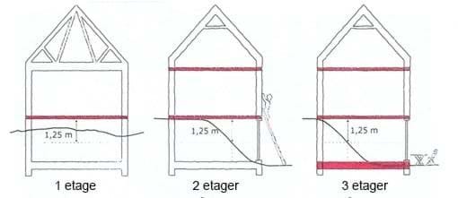
(Source: SBI Instruction 216: Instruction on building regulations 2008)
Each floor of the building, including the ground floor, is included in the number of floors. The number of floors also includes usable attics where the threshold height is less than 1 m and basements where the ceiling is more than 1.25 m above ground level.
The maximum building height is stated in the overall provisions in the individual sub-areas as the maximum height at the roof ridge (tilt height).
In the case of a basement located at a level change in terrain, the general rule is that the basement is not considered a floor if there is a minor exposure in natural terrain, while a major exposure of the basement due to terrain differences will be considered a floor, as shown in the sketch above.
Road layout and road construction lines
New areas must be connected to the road network and satisfactory road access must be ensured. The road network is divided into four categories:
- Primary traffic roads - connecting the individual districts. The roads are characterized by heavy and through traffic. Light road users are separated. The road is unpaved and the permitted speed is 40 or 60 km/h.
- Secondary roads - connecting the individual neighborhoods within a city district. These roads are characterized by a lot of car traffic, but not so much heavy traffic. The light road users are separated from the heavy ones. The road is frontless and may have restricted access and the permitted speed is 40 or 50 km/h.
- Local roads - which ensure access to the individual sub-areas and ensure good accessibility and safety for everyone. The roads only serve local traffic and are therefore characterized by low or moderate traffic. The road users can be both mixed and separated. The permitted speed is 30 km/h. The roads only serve local traffic and are therefore characterized by moderate traffic. The road users can be both mixed and separated. The permitted speed is 30 km/h.
- Closed roads – serving local areas and individual homes, workplaces, institutions and shops, and have low traffic. All road user groups are mixed and can be established as “Play and living areas” with a permitted speed of 15 km/h.
When planning the road network, new roads should only be connected to roads of the same or adjacent class.
Road charges
The allocation of area for roads includes the roadway, possibly sidewalks, ditches, wiring and snow removal, etc. New roads must - unless special circumstances dictate otherwise - be allocated the following widths, including shoulders/ditches:
- Primary traffic roads: 25 m
- Secondary traffic roads: 16 m
- Local roads: 10 m
- Closed roads: 6 m
Primary and secondary roads appear on the main structure map for each city.
In settlements, area is laid out for roads, lanes, etc., which – unless special circumstances dictate otherwise – must be laid out 8 meters wide, including verges/ditches and the like.
Road construction lines
When drawing up detailed regulations, unless special circumstances dictate otherwise, an attempt must be made to establish building lines along major roads at the following distances from the road centre:
- Primary traffic roads: 15 m
- Secondary Traffic Roads: 10 m
- Local roads: 7.5 m
- Closed road: 3.0 m (serving only a few homes)
In the detailed regulations, road construction lines can always be determined at a greater distance from the road center than specified above.
No construction or other facilities are permitted within the construction lines that may hinder the operation of the road system, including snow removal, repairs, etc.
Parking
The necessary number of parking spaces must be established for new construction and new functions. Unless otherwise stated in the detailed provisions of the municipal plan, the following minimum requirements apply:
- For single-family homes/townhouses with individual parking: 2 parking spaces per home
- For single-family homes/townhouses with shared parking: 1 parking space per home
- Apartment buildings: ½ parking space per apartment
- Dormitories etc.: 1 parking space per 5 residences
- Institutions: 1 parking space per 50 m2
- Office building: 1 parking space per 50 m2
- Factory and workshop construction: 1 parking space per 50 m2
- Warehouses: 1 parking space per 100 m2
- Restaurants etc.: 1 parking space per 10 seats
- Grocery and specialty stores, kiosks and grills: 1 parking space per 25 m2 of sales area
- Shops with space-consuming goods: 1 parking space per 100 m2
- Other construction: To be determined in each individual case
Parking must, as far as possible, be established in direct connection with the buildings or facilities in question. The parking area must, as far as possible, be paved, drained and kept tidy.
When establishing shared parking spaces with more than 5 spaces, it must be possible to establish and install charging stations for electric cars.
In the specific case, the parking requirement is stated in the area allocation, which may also include requirements on how many parking spaces must be established before the construction is put into use.
The Municipal Council may, where special circumstances apply, deviate from the parking requirement, taking into account the use. The requirement can be both stricter or more relaxed in relation to the provisions of the municipal plan.
Sled tracks and paths
Sled tracks must be secured so that good connections are ensured from the built-up area to the hinterland, the sea ice and out to the fishing areas. Sled tracks appear on the main structure map for the individual town or settlement.
Paths, stairs and path systems must be ensured in conjunction with roads so that pedestrians can travel between the individual areas. The primary path connections appear on the main structure map for the individual city or settlement.
No buildings or structures may be erected or objects, etc., placed that prevent the use of sled tracks or paths.
Availability
When designing roads, paths, buildings and other facilities to which citizens must have access, the aim must be to ensure that accessibility for people with walking difficulties and the disabled is as good as possible, and this must therefore be taken into account.
The detailed planning must establish provisions that aim to establish equal access for everyone, including ensuring that the elderly and disabled can move around everywhere in the urban environment.
Technical supply
New buildings must be connected to public electricity supply, district heating supply, water supply and sewerage, if this has been proposed and the possibility has been established.
In cases where it is not yet possible to connect to the public sewer, the municipal council may require the establishment of a tank for collecting grey and black wastewater, or the establishment of other wastewater treatment in accordance with the applicable environmental regulations and rules for the disposal of grey and black wastewater.
It is the responsibility of the individual homeowner to ensure that grey wastewater discharged onto the ground does not cause a nuisance to neighboring properties or to public traffic on roads and paths. Nighttime sewage may only be discharged if the health authorities have approved the individual sewer outlet and environmental approval has been obtained. Emptying nighttime sewage bins on the ground or in the harbour is not permitted, with the exception of emptying from a nighttime sewage ramp.
Discharge of oil, gasoline and chemicals onto the ground, into drains or ditches is not permitted.
Surface water, including roof water, must not be discharged to public sewers, but must be drained in such a way that it does not cause any nuisance to surrounding buildings, roads, paths and undeveloped areas.
Water, electricity and sewage pipes, TV cables, etc. must be laid underground where possible. Areas above pipelines may not be built on unless special circumstances warrant it.
If lines cross roads or paths, suitable crossings, stairs, footbridges, etc. must be established to ensure traffic in the area. The line owner may require the rerouting of the line system if this is not observed. Any rerouting of the line system is free of charge for the line owner and must follow the line owner's rules.
When detailed planning new urban areas, routes for the routing of electricity, water and sewage pipes, etc., must be determined as far as possible.
Conservation and preservation interests
In general, work is carried out with Overarching conservation and preservation interests:
- Includes national conservation areas, area conservation areas and listed buildings.
- Must be incorporated into the municipal plan.
- Also contains conservation areas designated based on the Yellow City Notes as well as buildings worthy of preservation designated by the municipality.
General rules for Listed buildings and structures:
- May not be demolished, rebuilt or altered without approval from the National Museum and Archives of Greenland.
- A list of listed buildings can be viewed at the National Museum of Greenland.
The Municipal Plan's Protected Areas in urban and rural areas:
- Must be kept unchanged.
- No changes to terrain, planting, buildings or structures without permission from the relevant conservation authority.
- A list of protected areas can be seen in the Planning Statement.
Owner's Maintenance of listed buildings:
- The owner is responsible for maintenance.
- All alterations (interior and exterior) require prior permission from The Cultural Heritage Council.
- The area is regulated by Inatsisartutlov no. 11 of 19 May 2010 on conservation and cultural heritage protection.
- The National Museum of Greenland has the authority.
Areas and buildings for Conservation areas and buildings:
- Must be preserved and incorporated into the municipal plan.
- Regulated by Home Rule Order No. 31 of 30 October 1991 (The conservation order).
A distinction is made between:
Particularly valuable conservation areas:
- The municipality must establish clear guidelines in the municipal plan.
- Changes require approval from the Government of Norway.
- The boundary is determined by the Naalakkersuisut (County Government) after negotiation with the municipality.
Areas worthy of conservation:
- The municipality determines the extent of the conservation.
- Typically includes construction from the 1950s-1960s.
- The boundary is determined by the Naalakkersuisut (County Government) after negotiation with the municipality.
Building changes Extensions and new buildings in conservation areas:
- Must be adapted to the character and distinctiveness of the building.
Provisions Criteria for buildings worthy of preservation:
- The building is assessed based on architectural or construction-technical qualities.
- Not just age or beauty, but also its uniqueness for its time or house type.
- The municipalities are responsible for the administration.
- Renovation and maintenance must be carried out with respect for the original design, construction and choice of materials.
The Yellow City Notes
National Planning Directive Status and significance:
- Functions as national planning directives in Greenland.
- Guidelines for the preservation of buildings and areas worthy of preservation.
- Published by the Directorate of Economics in 1990 for each city.
- Incorporated into the municipal plans and must be accessible via NunaGIS.
Changes or repeals Process for change or repeal, where the municipality must:
- Identify the status of the area (specially valuable conservation area or area worthy of conservation).
- Prepare proposals for changes to the municipal plan.
- Obtain approval from the Government of Denmark for particularly valuable conservation areas.
- Conduct public consultation.
- Adopt the changes after consultation and adjustments.
- Obtain final approval from the Government of Denmark for particularly valuable conservation areas.
The Ombudsman The Ombudsman's assessment (2013):
- Conservation status can be granted via municipal decision or national planning directive.
- The Yellow City Notes have legal validity as national planning directives.
Dispensation request The Conservation Order and dispensation options:
- Executive Order No. 31 of 30 October 1991 requires municipalities to protect the most valuable conservation areas.
- No exemption provisions.
- Deviation can only be made via municipal plan supplement and approval from Naalakkersuisut.
Planning Act Particularly valuable conservation areas:
- The Planning Act (Section 20(5)) requires provisions on:
- Protected or conservation-worthy features (buildings, facilities, areas).
- Culturally and historically valuable areas.
- No exemptions from the conservation provisions.
- Municipal plan amendments may allow for deviations.
- The Government of Greenland has the right to object to changes.
Department of Law and National Planning Procedures for amending conservation regulations
- The Legal and National Planning Department must, prior to the decision of the Greenland Government:
- Obtain ratings from:
- Greenland National Museum and Archives.
- Ministry of Commerce.
- Affected builders.
- Prepare an assessment of advantages and disadvantages, including:
- The architectural, cultural-historical and economic significance of the preservation (e.g. tourism).
- The development needs of the city and society.
Miscellaneous Other areas worthy of conservation:
- The municipal plan must address these areas.
- Typical buildings from the 1950s-1960s.
- The Government of Greenland may raise objections.
No exemptions from Section 3 of the Conservation Order.
Dog training
In Municipality Qeqertalik, dog ownership is regulated to ensure appropriate placement and compliance with applicable regulations.
- M-areas in the open countryside: The location of dog parks on Dog Islands in the open countryside (M-areas) is determined in the main structure of the municipal plan.
- qeqertalik.gl
- Free-range D-areas: Dog kennels can be established in all free-range D-areas after a specific assessment and individual approval by the municipality.
- qeqertalik.gl
- For existing homes: Dog kennels can be established in connection with existing homes, provided that the location is individually approved by the municipality.
- qeqertalik.gl
- Temporary use: Sub-areas planned for other future uses can be used for dog keeping until development begins.
Compliance with local bylaws All dog teams must comply with the current "Bylaws for cat and dog teams in Municipality Qeqertalik" at all times.
Containers
In special cases, permission may be granted to erect a container in residential and downtown areas. This permission may only be time limited. Requirements may be made that the cladding, color and use be adapted to the area in which a container is erected.
If containers are to be used as sheds etc. in residential and centre areas etc., this can only be done after permission from the municipality and by handling the containers as an outbuilding, which is clad with wood and/or painted in accordance with the colours of the main building.
The Municipal Council can designate container areas in the cities where both private individuals and companies can store closed containers.
Containers can be placed in the following cases:
- During a construction period, in connection with construction sites for new construction, alterations and extensions. Containers must be removed no later than in connection with notification of the commissioning permit.
- In connection with moving for a maximum of 4 weeks.
- In commercial areas, a company can set up to 6 20-foot containers on its own storage area when the containers are painted in the same color as the company's buildings.
land allocation at any time.
Boat storage
Winter storage of boats can take place in areas designated for commercial and port purposes, or in areas designated for boat storage in the municipal plan. Winter storage of boats can be permitted in connection with single-family homes, when the boat and homeowner are the same person, a maximum of one boat per home. Winter storage of boats can be permitted in connection with cooperative or rental housing, when there is an acceptance from the lessor/owner, and in connection with a company to which the boat owner is affiliated. Boat storage requires, with a few exceptions, an area allocation, which can only be time limited.
Boat storage must comply with the "Bylaws for Boat Storage in Municipality Qeqertalik" in force at any time.
Port authority area
The Government of Greenland has designated port authority areas in all towns and settlements where there are permanent facilities. Port authority areas include, to varying degrees, both land and water areas where the Government of Greenland is the authority. Designations can be viewed at www.nunagis.gl
This delimits and establishes authority responsibilities for both cleaning and removal of shipwrecks and other floating objects, both regulated by the applicable port regulations.
Within the designated areas, the Government of Greenland is the authority. The central port authority is the Department of Municipalities, Settlements, Outlying Areas, Infrastructure and Housing. The local port authority is delegated to RAL. This also applies to the water area in the inner harbour.
In the land area in the inner harbor (on the inside of the port authority area) and towards the sea, authority is also delegated to the municipality with regard to cleaning and waste disposal.
Pollution in the water area is regulated by the Danish Marine Environment Act and the Ministry of Nature and Environment is the authority in all cases.
Removal of shipwrecks and other floating objects in the sea area outside the ports is regulated by the Danish Maritime Authority in accordance with the Act on Safety at Sea. The authority is the Danish Maritime Authority.
Ministry of Municipalities, Rural Areas, Outlying Districts, Infrastructure and Housing - Note:
This memorandum from the Government of Greenland describes in detail where the cleanup responsibility lies within the different types of authority areas.
port authority areas_dk.pdf (1.1 MB)